|
|

|
|
|
|
ECLIPSE |
|
WEATHER |
|
TELESCOPES |
|
TOUR |
|
LINKS |
|
MAP |
Weather-forecast in Siberia on 2008 August 1st
As the path of the lunar shadow moves southward across central Russia, it encounters a moist landscape of rivers, bogs and small lakes. The surface provides a ready supply of moisture to be incorporated into passing weather systems. Most of these weather systems track north of the 60th parallel, but their associated frontal systems can sweep much farther south, even into China. The weather in the north has a very different character than that in the south. Above the 60th parallel, large weather systems with extensive mid- and upper-level cloud shields and steady precipitation are a common feature of the mid-summer months. Farther south, nearer to Novosibirsk, the weather systems become more convective in nature, with showers and thundershowers bringing the majority of the rainfall.
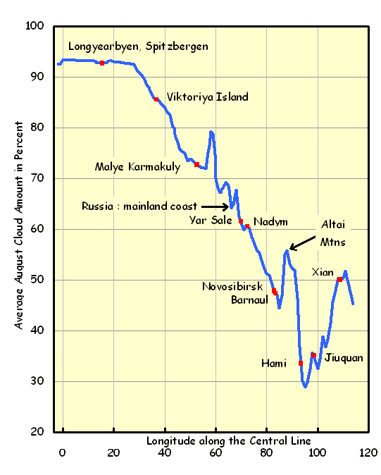
There is not a clear-cut distinction between the northern and southern cloud climates, but instead a gradual transition as latitudes decline. In the satellite data, mean cloudiness diminishes steadily, from 65% along the north coast near Nadym to 47% near Barnaul (Figure 1). South of Barnaul cloud cover increases by nearly 10% over the rugged Altay Mountains. Surface observations show the percent of possible sunshine climbing from a mediocre 35% at Salekhard to a more promising 54% at Novosibirsk and 57% at Barnaul. 
Graph 1 : Graph of mean August cloud amount along the eclipse centerline. The data were extracted from satellite imagery collected between 1981 and 2000. Geographical sites plotted along the graph are not necessarily within the eclipse track but projected onto the track to provide approximate location information. Data courtesy NOAA and the Pathfinder Project. For those inclined to travel far to the north in Siberia for the eclipse, the most likely destination is Nadym, just below the Arctic Circle. A small community of fifty-thousand composed of imposing bastions of apartments, Nadym owes its existence to the huge reserves of natural gas that can be found in northern Siberia. As climate statistics are not available for Nadym, Tako-Sale or Salekhard can be substituted. In either case, cloud cover statistics are not encouraging, in large part because of the frequent presence of migrating low-pressure systems with their large cloud shields and sustained precipitation. In Figure 1, Nadym looks promising only when compared with sites much farther north. Much of the summer precipitation in the southern portion of the Siberian track is a showery type brought on by the initiation of convection during the passage of weak frontal systems. These disturbances pass relatively quickly and are easily followed in satellite imagery by noting the areas of mid and high-level cloudiness that usually accompany them. Such systems can bring a day or more of cloudiness, in contrast to less organized forms of convection that may persist for only an afternoon and evening. Whatever its nature, most days with rain are supported by some form of upper disturbance and eclipse expeditions should keep an eye on numerical-computer models, as these are quite reliable at forecasting the movement of the upper systems. The Altay Mountains, with peaks rising above 4000 m, impose a substantial barrier between Russia and China and separate two very different climate regimes. Their altitude brings a sharp increase in cloudiness as air is forced to rise and cool, but the spectacular beauty of the area, with brilliant glaciers and snow-capped peaks, provides a powerful temptation to go to the border for the eclipse. The climate in the Altay is highly variable, with high, steeply sloped mountains alternating with deep valleys. The rugged terrain breaks holes in all but the most persistent weather systems, but the difficulty of travel and the limited horizon view makes the task of finding a sunny spot or avoiding cloud a difficult one. Given the challenges, the most promising weather would seem to lie on the south side of the Altay, close to the border with Mongolia, where the climate is much drier. Temperatures moderate significantly once the eclipse track leaves the Arctic coast for the interior of Siberia. August 1 is just past the warmest part of the year: maximum temperatures climb from an average of 13° in the north to between 21° to 23° near Novosibirsk and Barnaul. Rainfall is infrequent in the afternoon - on average, about 15% of the hours around the time of the eclipse have precipitation reported. It's not a particularly breezy time of year (maximum winds seldom exceed 40 km/h), but strong thunderstorms can bring damaging gusts just as occurs in North America or Europe. The likelihood of a thunderstorm during the afternoon ranges from less than 1% over the northern part of the track to between 3 and 5% south of Novosibirsk. Local weather conditions around NovosibirskNovosibirsk is likely to be the staging point for eclipse expeditions to southern Siberia as it is a substantial metropolis with all of the services that come with a large population. The surrounding landscape is a mixture of forest and farmland, with good highways to the east, west, and south. Of particular interest is the highway that leads southward from the city toward Barnaul and the Mongolian border: it follows the centerline very closely for the first 300 km and then more loosely for the remaining distance. The centerline of the eclipse shadow misses the Novosibirsk to the west, passing directly over the airport near the town of Ob.
Figure 3: The Ob River near Novosibirsk and the surrounding countryside. A line of scattered showers was crossing the city as this photo was taken; skies cleared shortly thereafter. 
Figure 4: A view of the beach and shoreline at Leninskoye. The Ob Reservoir is visible in the background. A broad sandy beach fronts the shoreline, with moderately steep hills farther inland. There is road access to the beach in this location. The landscape is generally flat, though in some directions, open spaces for eclipse observing are at a bit of a premium because of the surrounding forests that crowd the roads (Figure 3). A little searching will find open fields - generally meadows - that offer a broader vista (Figure 5). The area is largely unpolluted, thanks to the vast Siberian wilderness, though occasional forest fires have been known to put a pinkish cast onto the sky. The Novosibirsk Reservoir (informally, the Ob Sea), to the southwest of the city, is a large lake with a long dimension of over 100 km and a maximum width of nearly 20 km. The size of the lake and its cool waters plays havoc with convective clouds - small and medium-sized buildups dissipate rapidly as soon as they cross from land to water, often opening substantial holes in the cloud cover when conditions are right. Eclipse-viewing sites situated on the lee side (which changes with the wind direction) of the lakeshore could derive a substantial benefit from this effect, especially as the centerline crosses the lake only 20 km from Novosibirsk. The suppression of cumulus cloudiness usually extends a short distance inland on the lee shore. 
Figure 5: A view of the landscape 10 km to the south of Novosibirsk Airport, on the way toward Leninskoye. Plenty of open space is available in this location, though a few kilometres off the centreline. 
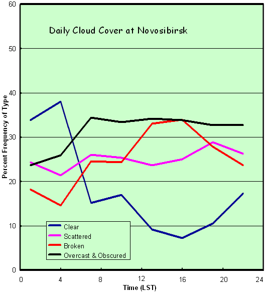
Figure 6: South of the airport (which lies immediately to the right). The area is industrialized and the ground rough, but could be used in a pinch for eclipse observing. This area is on the centreline. Examination of the hourly cloud-cover statistics for Novosibirsk (Graph 2, below) shows a strong increase in broken cloudiness during the afternoon hours and a corresponding decrease in clear-sky conditions.This pattern is almost certainly a climatological reflection of the buildup of cumulus cloud as a result of daytime heating. Essentially, clear skies are being traded for broken cloudiness during the daytime hours at Novosibirsk. In spite of the ominous nature of the pattern, it is actually quite promising for eclipse-chasing, as it implies that the onset of cooler temperatures as the Moon's shadow approaches will result in the dissipation (or at least a decrease) in cloud cover. It also suggests that a site on the lakeshore should be able to improve odds (i.e. the percent of possible sunshine) by 5 to 10 percent above the statistics for Novosibirsk airport. The airport lies 24 km to the north of the lake. Showery weather typically arrives with a southerly component to the wind, and so the north side of the lake is slightly more favored by climatology than the south. 
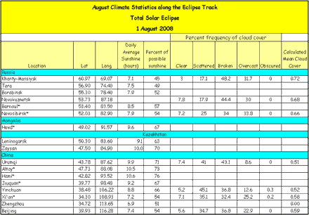
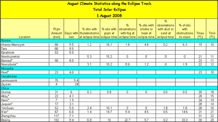
Graph 2: Percent frequency of clear, scattered, broken and overcast cloud conditions in August at Novosibirsk. The center of the eclipse track crosses the town of Leninskoye on the north side of the lake and Sosnovka on the south, both of which are easily accessible from Novosibirsk. Sosnovka is a tiny community located next to a creek of the same name. The terrain is open to the southwest and to the north across the lake, providing an excellent view of the oncoming shadow, and the surrounding countryside is largely made up of open farmland (Figure 5, 6). There is no beach along the shore, but an open space next to the waterline affords an place for viewing the eclipse. Leninskoye, on the north side of the lake, has the attraction of a large beach (Figure 4) that permits an excellent view southward. The beach, or the high ground that backs the beach, offers more space than appears available at Sosnovka. Leninskoye itself has limited facilities but is undergoing rapid development as residents from Novosibirsk build dachas (country houses) in the community. Closer to Novosibirsk, the town of Ob - essentially an airport suburb - nearly straddles the centreline, but there are few open spaces to catch a good view of the horizon and the ambiance is overly industrial with noisy traffic on the highway leading to Omsk (Figure 6). South of Ob lies a stretch of farmland with open pastures mixed with patches of forest - an attractive area with plenty of space (Figure 5). Tables: Table 1: Climatological cloud statistics for sites along the eclipse track. Description of elements: Hourly sunshine: mean daily number of hours in August with bright sunshine. Data from various sources. Percent of possible sunshine: the percent of time from sunrise to sunset represented by the hourly sunshine in the previous column. This statistic is probably the best for determining the probability of seeing the eclipse. Data from various sources. Percent frequency of clear, scattered, broken, overcast, and obscured cloud conditions: Clear skies are those with less than 1/10th sky cover; scattered, 1-5 tenths; broken, 6-9 tenths; and overcast, 10-tenths. Data are for the time of day closest to totality, broken into three-hour intervals (0, 3, 6, 12…). Data from the International Station Meteorological Climate Summary. Calculated Mean Cloud Cover: A weighted average of the cloud cover statistics in the previous columns. Scattered cloudiness is given a weight of 0.25, broken cloudiness, 0.75. This figure is useful for comparative purposes, but not for absolute determination of the probability of seeing the eclipse. Table 2: Climatological statistics along the eclipse track. Data are for the time of day closest to totality, broken into three-hour intervals (0, 3, 6, 12…). Data from the International Station Meteorological Climate Summary (NCDC). Description of elements: % obs with…: Percent of observations with the indicated element. "Obstructions to vision" includes fog, haze, and blowing snow, dust, or sand. Data are for the time of day closest to totality, broken into three-hour intervals (0, 3, 6, 12…). Data from the International Station Meteorological Climate Summary (NCDC). Tmax, Tmin: average maximum and minimum temperatures. Data from various sources.
From “Eclipse Weather and Maps” site by Jay Anderson (Canada) -
http://home.cc.umanitoba.ca/~jander/ |
|
|
||||||||||
| Total Solar Eclipse of 2008 August 1st in Siberia :: Eclipse :: Weather :: Telescopes :: Tour :: F.A.Q. :: Map | ||||||||||||


